COURTESY TRANSLATION IN ENGLISH FOR EUROPEAN UNION OPERATORS COMING TO PORTUGAL
All approvals, including the proof of completion of online training, the certificate of competency in the Open Category or the confirmation of declarations and operational authorizations in the Specific Category operators are mutually recognized within the European Union.
1. OPEN CATEGORY OPERATION IN PORTUGAL CONDUCTED BY OPERATORS REGISTERED IN ANOTHER EUROPEAN UNION MEMBER STATE
UAS operators and Remote pilots of the Open Category can operate in another EU Member State with the same competency documents issued by the member state of registry or that issued the certificate. However, they must verify if specific legal requirements of that Member State are applicable, namely regarding the prohibitions or access restrictions in some geographical zones (https://dnt.anac.pt).
Other legal rules that are not directly related to aviation may also apply (local conditions), namely regarding sovereignty, privacy, insurance, environmental and noise. Operators of unmanned aircraft systems that operate under the open category requirements and intend to operate in another Member State are responsible for collecting the necessary information.
An open category UAS operator registered in another Member State of the European Union can operate in Portugal without prior authorization (only provided if in the specific category e.g. CBO) from the Portuguese Civil Aviation Authority (ANAC). The rules of the open category and its subcategories should be followed. If these rules and procedures are not possible to comply (open category limitations), the operator should not start an operation.
All EU UAS operators, namely those operating in the open category, need to have in mind that the state implemented national geo-zones (GZ). You shall adhere to Portuguese GZ access conditions.
- To operate in Portugal in the open category, the UAS operator registered in another European Union country shall comply with the following conditions:
Have a valid UAS operator registry number issued by an EU Member State. The UAS operator number must be attached to the ‘drone’ frame and an active and UpToDate remote identification system must be used when the UAS have such functionality (C1, C2, C3, C5 and C6 or in case an attached system is available) and in accordance with what is required in terms of airspace (for example geographical zones);
- Operate a C class labeled UAS suitable for the open subcategory (A1, A2 or A3), or when without, the operation will be limited to A1 (less than 250g) and A3 (any up to 25Kg) subcategories;
- The operator should verify the geographical zones (GZ) published here (https://dnt.anac.pt). JSON format is available here (ED-269 / ED-318 standard) to be uploaded to the compatible UA.
Download the tutorial for the geographical zones here:
TUTORIAL ZONAS GEOGRÁFICAS (PT e EN)
Regarding local conditions, please take in mind that the military authority may issue a ZEA (“Zona de Exclusão de Espaço Aéreo”, Airspace Exclusion Area/No Fly Zone). A ZEA is a short notice airspace prohibition (to all civilian aviation, manned and unmanned), implemented in a limited timeframe for a military and law enforcement operation aiming internal security and military objectives. The ZEA is established by AAN. We strongly suggest to verify the local conditions available in the point 4 “summary”, the tutorial and the AAN temporary restrictions available in this webpage.
Finally, if you intend to operate in a ZG in which ANAC is the “Manager” it means that you fall automatically in the specific category (no possible to operate in the open category) and the only available option is hold a valid operational authorization OAT or a Light Unmanned UAS operator certificate (LUC) issued by your state or registry and request an CBO to ANAC
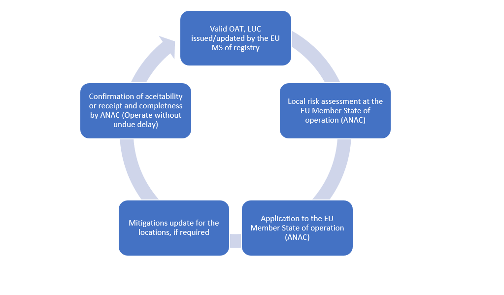
2. CROSS BORDER OPERATION (CBO) IN THE SPECIFIC CATEGORY - OPERATOR REGISTERED IN ANOTHER EU COUNTRY INTENDING TO OPERATE IN PORTUGAL WITH THE OPERATIONAL AUTHORISATION (OAT) or LUC ISSUED BY THE MEMBER STATE OF REGISTRATION
Operational authorizations of the Specific Category and LUC, issued by your country of registry, are recognized in all European Union Member States, including in Portugal.
When the operator intends to use a valid operational authorization (OAT) or LUC issued by is state of registry in Portugal (conduct a cross border operation), the UAS operator has to ensure that in the location of operation in Portugal, the conditions are identical to those observed in the area over which the authorization was issued or aligned with LUC privileges imposed by his Member State of registry.
The UAS operator (OAT or LUC without proper privileges) must perform a local assessment (verification of local conditions) in the area of operation that include an airspace analysis (e.g. geographical zones, airspace classification and other airspace management local conditions), terrain and demographic characteristics (e.g. static and dynamic population density), as well as climatic conditions (e.g. weather).
If you are an UAS operator registered in another EU state, holder of a valid OAT or LUC and you intend to operate in Portugal, you shall submit a cross border application to ANAC as per article 13 of Commission Implementing Regulation (UE) 2019/947. Please take in mind that a local assessment (verification of local conditions) is always required and you should verify if the mitigations in the OAT are compatible to the location of operation in Portugal.
LUC holders can carry out cross-border operations in any EU Member State without the need of issuance of a new LUC or operational authorization request. They only have to submit to the Competent Authority of that Member State the LUC issued by its member state of the registry and the locations (s) of operation were is possible to operate under the LUC privileges. ANAC will process the application request in the same way as a cross border operation where an OAT is used. A confirmation of acceptability is provided and may be used to facilitate or allow coordination with other entities or authorities.
In case of a LUC you should ensure that the privileges could be applied according with the local conditions (specific to the area of operation in Portugal) and the expectation is that your management system during the execution is able to identify if it is possible or not to conduct the operation.
If the local assessment identifies the need to adjust significantly the SORA that supported the OAT, most probably the CBO will not be issued. If the mitigations can be accepted, meaning, a change in the mitigations is required due to the local assessment (e.g. different air risk), if considered tolerable, ANAC could input in the cross-border authorization the need to update the mitigations and the authorization will be issued to the UAS operator and to the competent authority that issued the OAT. Such mitigations need to be updated in the OAT by the counterpart NAA/CAA (issue a revision of the OAT and include new locations if deemed necessary). If the mitigation is not relevant (e.g. remarks or observation) and do not impact the SORA document and OAT (e.g. change the air risk, ground risk, SAIL), probably there is no need to input substantial changes. Anyway, the country that issued the OAT (state of registry) is the responsible to decide and update the mitigations specific for the location available in the CBO (input by the State of operation).
It is suggested that UAS operators, before any cross-border application, prior the preparation, consult the useful information available in this webpage.
Regarding the local conditions for both categories (open and specific), an essential part of information is the national geographical zones available in JSON format in accordance with ED-269 AND ed-318 standardS (single common digital format referred into the n.º 3 of article 15.º of Commission Implementing Regulation (EU) 2019/947, available on the subpage “Zonas Geográficas e Espaço Aéreo U” (here) or in gz Map viewer (here).
The operator of the specific category intending to conduct a CBO shall submit to ANAC an application using the proper template and the local assessment document specific for the location of operation. Due to the national conditions, need to coordination with other domains and state entities, the location(s) must be know precisely including if the UAS operator is a holder of a generic OAT. The operator may commence the operation as soon as ANAC issue the CBO.
ANAC issue a confirmation of acceptability or a confirmation of receipt and completeness. The confirmation of acceptability template provided in EASA AMC is used for both situations.
UAS Operator registered in EU Member state (MS) intending to operate in another EU Member State (Portugal)
2.1. If using an OAT the following documents are required:
- Filled and signed application form;
- A copy of the operational authorization issued by the competent authority of the MS of registration, or a copy of the LUC terms of reference if the operation is conducted under the privileges of the LUC;
- Those chapter(s)/section(s) of the operations manual (OM) providing the operational procedures and the relevant information, amended as necessary, to comply with the local conditions and apply the mitigation measures to the new intended location(s), unless the UAS operator holds a LUC with the appropriate privileges; and
- Evidence of compliance of the amended procedures (refer to previous point) according to the level of robustness of the mitigation measures, if any, unless the UAS operator has a LUC with the appropriate privileges.
Note: An ANAC decision is always required including If the LUC holder have the privilege to apply local conditions. If the privileges include an airspace reservation as a mitigation, the local conditions related with the Portuguese airspace management require an ANAC decision. No civilian airspace allocation is possible (e.g. NOTAM, airspace reservation) in the Portuguese Airspace without an approval of ANAC. Any airspace allocation needs to be limited in time and airspace (minimum to achieve the objective). The airspace should be used efficiently, meaning that NOTAM with low rate of utilisation, blocking the access to other undertakings, for example, UAS operators and manned aviation airspace users isn’t tolerable. The concept of continuity and availability of airspace should be always be present when proposing mitigations.
If operating in Portuguese Controlled airspace and no U-space is implemented, the UAS operators should contact and agree the coordination process with the ATS unit before submit the application to ANAC. If U-space is available a lighter process adjusted to the specific airspace could be proposed and included in the manual (coordination procedure only in case of emergency). The process of coordination could be different from unit to unit since the capacity to participate in the coordination could be reduced due to the high traffic demand and need to focus in ATC service provision.
The air risk increases in Portugal during the summer near the coastline (SPO manned operations and crowded beaches) and in AGIF wildfire risk priority areas (low level operational and training manned aviation operations during the wildfire season). The operation is conducted both by civilian and military aircrafts (real operations and training). Lakes, rivers and dams or internal waters will have an increased encounter risk (ditching training to collect water). A failure to properly assess these local conditions, information available in AIP supplements, NOTAMs or in public state information could lead to a situation of not issuing the confirmation of acceptability or of confirmation of receipt and completeness.
2.2. If using a LUC:
- Filled and signed application form;
- A copy of the terms of approval received in accordance with point UAS.LUC.050 of the Annex to the UAS Regulation; and
- The location(s) of the intended operation in accordance with paragraph 1(b) of Article 13(1) of the UAS Regulation.
Note: An ANAC decision is always required including If the LUC holder have the privilege to apply local conditions. If the privileges include an airspace reservation as a mitigation, the local conditions related with the Portuguese airspace management require an ANAC decision. No civilian airspace allocation is possible (e.g. NOTAM, airspace reservation) in the Portuguese Airspace without an approval of ANAC. Any airspace allocation needs to be limited in time and airspace (minimum to achieve the objective). The airspace should be used efficiently, meaning that NOTAM with low rate of utilisation, blocking the access to other undertakings, for example, UAS operators and manned aviation airspace users isn’t tolerable. The concept of continuity and availability of airspace should be always be present when proposing mitigations.
If operating in Portuguese Controlled airspace and no U-space is implemented, the UAS operators should contact and agree the coordination process with the ATS unit before submit the application to ANAC. If U-space is available a lighter process adjusted to the specific airspace could be proposed and included in the manual (coordination procedure only in case of emergency). The process of coordination could be different from unit to unit since the capacity to participate in the coordination could be reduced due to the high traffic demand and need to focus in ATC service provision.
The air risk increases in Portugal during the summer near the coastline (SPO manned operations and crowded beaches) and in AGIF wildfire risk priority areas (low level operational and training manned aviation operations during the wildfire season). The operation is conducted both by civilian and military aircrafts (real operations and training). Lakes, rivers and dams or internal waters will have an increased encounter risk (ditching training to collect water). A failure to properly assess these local conditions, information available in AIP supplements, NOTAMs or in public state information could lead to a situation of not issuing the confirmation of acceptability or of confirmation of receipt and completeness.
The list of Competent authorities is available in EASA website. The available contacts could be used to inform your NAA. (https://www.easa.europa.eu/en/domains/civil-drones/naa).
2.3. Specific Category (STS)
If the UAS operator that declared his STS operation in another EU member state (of registry) and intends to operate according to a standard declarative Operation Scenario, to which he already holds the confirmation of receipt and completeness issued by his Member State of registry, he must submit to Member State of operation (in Portugal ANAC), the declaration and a copy of the receipt and confirmation of completeness. When submitted the operator could start the operation, unless the objective in conduct practical training activities. You should be aware of the national geographical zones and local conditions that can cause a negative impact (e.g. ZG, wildfire, security, privacy and noise national rules). The documents required for UAS operators is:
- STS Declaration;
- Confirmation of receipt and completeness of the STS.
Regarding recognized entities or operators to conduct STS practical training, registered in other EU member state and intending to provide the training in Portugal, he should consider the local condition in force by the national Regulation No. 372/2023, that establishes the process for recognition of practical assessment training organizations in the European STS. The documents required for UAS operators that conduct a CBO for practical training in Portugal are:
-
UAS operators recognized to perform practical training (conduct training only to remote pilots of the operator)
- A document in Portuguese informing ANAC;
- The operational declaration for that STS and the respective confirmation of receipt and completeness;
- The declaration in Appendix 4 of the Annex to the European UAS Regulation;
- A description of the representative locations for the purposes of ensuring that it operates in representative sites in the same way as recognized national organizations (STS compatible locations/conditions) as well inform LEA;
- Up to date operations manual and adjusted to the specific national conditions (locations if Portugal where the training is conducted), that should be available in the event of inspection/enforcement by law enforcement or any other authority, namely ANAC.
Note: A change in the declaration could be required to update the OM with the practical training locations. Please contact your state of registry. Contact your authority first.
-
UAS operator that is a recognized entity to perform practical training (conduct training to any remote pilot candidate of any organization)
- A document in Portuguese informing ANAC;
- Recognition document issued by the state of registry;
- A description of the representative locations for the purposes of ensuring that it operates in representative sites in the same way as recognized national organizations (STS compatible locations/conditions);
- Up to date operations manual and adjusted to the specific national conditions (locations if Portugal where the training is conducted), that should be available in the event of inspection/enforcement by law enforcement or any other authority, namely ANAC.
Note: A change in the declaration could be required to update the OM with the practical training locations. Please contact your state of registry.
The expectation for the STS organisations (operators or recognized entities) is that you have already your manual and procedures adapted to Portugal local conditions. We strongly suggest to provide in advance information about the locations to add information relevant to law enforcement and military entities.
Note: A power attorney is accepted in case the UAS operator chose to have a representative in Portugal to liaise with ANAC. The limits should be established in the document (e.g. level of empowerment, matters and scope etc.).
2.4. Procedure to be applied in the case of a UAS operator registered in another EU country and intending to operate in Portugal
To apply for a CBO:
a) Go to “Formulários”, fill and sign CBO application template “4. Operações Transfronteiriças / Cross border operations” (here);
b) Depending the type, authorization (OAT), declaration (STS) or certificate (LUC), assemble the application documents as referred in 2.1., 2.2. or 2.3, as applicable;
c) Submit the documentation package via email uas.spec@anac.pt.
According with portuguese CPA (Código do processo Administrativo):
- The language of application is Portuguese but we accept documentation in English. If the manuals and documents aren’t written in English you need to provide and authenticated translation provided by official translator. To avoid unnecessary delays, we strongly suggest to have all signed/authenticated documents in English, including the OAT, LUC, confirmation of receipt and completeness and the relevant parts of OM (authenticates translation of the relevant chapters), as applicable.
- The CPA states that a decision must be taken in 60 days and an additional extension of 30 days is possible (total of 90 days). We strongly suggest to avoid unnecessary delays to find locations that match the conditions/mitigations of your OAT or privileges of the LUC. Is important to have the relevant parts of the OM already updated and approved in case new mitigations are required or need to be changed to avoid unnecessary delays.
Note: The CBO could be issued in 10 working days if quality documentation is provided (include proper assessment of the local conditions).
2.5. Considerations regarding the local air risk conditions
The UAS operator should consult the website of the Member State authority and request information, if necessary, in any state agency, including local information on geographical zones, terrain, population density, among others.
2.5.1 Considerations regarding the local air risk conditions in Portugal
2.5.1.1 Planning
In Portugal, for operators planning to operate in the national territory, in order to facilitate the calculation of the "Airspace Risk Category", using an operational authorisation (OAT) or a LUC shall, for the purposes of applying the risk analysis methodology, to demonstrate conformity with the acceptable means of compliance and guidelines of AMC1 of Article 11 of Implementing Regulation (EU) 2019/947 (SORA methodology), consider the following:
a) Flights in the prohibited areas international airports and police, customs and HEMS heliports, including areas 1 and 2, above the maximum allowed heights in controlled airspace are considered as operations in airport environment “ OPS in Airport / Heliport environment ”;
b) Operations above the heights mentioned in area 3 of international airports operational protection areas up to a maximum height of 150m above the ground, is considered to be an operation in controlled airspace “Controlled airspace”;
c) Flights in ATZ / TRMZ that require authorisation from ANAC, namely above 120 meters AGL, BVLOS , Swarms and over assemblies of persons, are assessed as “OPS in Mode C-veil or TMZ ”;
d) In all other circumstances, the operator must identify the ARC and apply the methodology explained in the SORA methodology to identify adequate mitigations to be submitted to ANAC.
Source:
Geo-zones: https://uas.anac.pt/registry/explore
Note: ANAC provide the ED-269 and ED-318 JSON format and initial Arc assignment to the geozones in the visualization webtool.
Geo-Zones Tutorial: Download the tutorial for the geographical zones here:
TUTORIAL ZONAS GEOGRÁFICAS (PT e EN)
Portugal Aeronautical information products: https://www.nav.pt/ais
As already states, the air risk increases in Portugal during the summer near the coastline (SPO manned operations and crowded beaches) and in AGIF wildfire risk priority areas (low level operational and training manned aviation operations during the wildfire season). The operation is conducted both by civilian and military aircrafts (real operations and training). Lakes, rivers and dams or internal waters will have an increased encounter risk (ditching training to collect water). A failure to properly assess these local conditions, information available in AIP supplements, NOTAMs or in public state information could lead to a situation of not issuing the confirmation of acceptability or of confirmation of receipt and completeness.
2.5.1.2 ARC-a and airspace allocations/reservation for a specific user
Arc-a is only accepted in places where the likelihood of encounter with another airspace user is so low that no strategic mitigation is required regardless of whether or not airspace segregation exists. Arc-a obtained through segregation of airspace shall not be accepted in controlled airspace or in uncontrolled airspace locations manned air traffic is expected , namely, airspace procedures, final ILS (10º each side of RWY centerline azimuth), runway departure end (10º each side of runway centerline), SIDs, STARs, above MVA or MSA, helicopter VFR routes/reporting points, or in existing functional blocks or temporarily created for that purpose where, due to air traffic in adjacent areas, there is a moderate or high probability of airspace infringement phenomena (Lisbon, Porto, Faro VFR tunnels, CTRs and in Portuguese Shoreline between Faro and Sagres, Sines to Brejos da Carregueira, Brejos da Carregueira to Cascais via VFR tunnels, Cascais to Peniche and Espinho to Porto.
Arc-a could be naturally accepted during the night in non-controlled airspace out of geographical zones, in military restricted or prohibited areas (operator must submit evidences that the military authority ensure segregation and a proof of authorisation is required to appraise for Arc-a), during the daytime in very low level, for example bellow obstacles or between buildings where horizontal shelter is possible and no adjacent airspace procedures are available (e.g. final ILS, VFR helicopter routes and reporting points) or in territorial waters if operating more than 2NM from the shoreline.
The national airspace is a continuum and its segregation in the national territory and waters is reduced to a minimum (airspace and period). Efficiency of is utilisation must be demonstrated and a DAA ("Detect-and-avoid") strategy can be required even if a NOTAM is approved (airspace infringement by GAT could always occur due to the large number of published NOTAMs). Any airspace reservation will affect other airspace users (manned and unmanned) thus it should be limited on time. All airspace reservations to civilian (national and non-national) requires an approval from ANAC as per CIA n.º 29/2013 (here). Such approval requires a decision of ANAC and when is issued will be included in the CBO confirmation of acceptability or receipt and completeness.
During the wildfire season most part of the non-controlled airspace is allocated by AIP supplement for civilian firefighting and military/state activities between 1500´ SFC up to FL050 (check the supplements or NOTAMs). Any airspace allocation above 150m AGL or 500´ AMSL will have a negative impact in GAT flying in the center and north sector (2/3 of the Portuguese mainland).
No restricted or prohibited areas will be created for the use of the UAS operators as a means of mitigating of the air risk if the operation is performed beyond 12NM, unless, in an air navigation safety context, the ATM/ANS provider considers especially important the publication of an airspace allocation or information for the activity. If the UAS operator submit a proposal for total segregation, it will be necessary to submit evidence of DAA integration to ANAC.
2.5.5.3. Declared STS UAS operators and airspace allocations
UAS Operators that declare STS can only operate in compliance with the conditions of the geographical zones and in the representative environments of the STS application in question (STS-01 and STS-02). No airspace allocation is possible.
3. SUMMARY OF LOCAL CONDITIONS
UAS operators intending to perform a CBO using a valid OAT or LUC should take into account the local information of Portugal, which may have an impact on their risk analysis. Therefore, if EU MS UAS operator plans to operate in Portugal, it has to check the local conditions for the specific location.
Thus, in Portugal, the following sources can be used by UAS operators for local assessment (OAT or LUC holders):
|
Subject |
Information |
Additional Guidelines |
|
Geographic Zones |
Geographic zones (GZ) published at
https://dnt.anac.pt |
ED-269 JSON and KML available in:
https://dnt.anac.pt
The viewer contains the geo zones in geoJSON format and also presents the areas of military jurisdiction, CTR’s, ATZ’s and TRMZ´s. Specific category operators may also consult the eAIP , eVFR and PIB/NOTAMs (https://ais.nav.pt ) for detailed information of the National airspace (AIP products)
ANAC provides a KML file with the assigned Arc for each GZ. The UAS operators should always consider the most restrictive Arc condition in case of overlapped ZG.
For example: If you are in a prohibited zone protection a EASA Aerodrome you should consider Arc-d.
|
|
Airspace |
National AIP and PIB/NOTAMs available at https://ais.nav.pt , especially if operating under the specific category. |
Obtain authorisation of an aerodrome or heliport director (updated contacts at eAIP and eVFR https://ais.nav.pt/ ), without CTR or ATZ, if intending to operate within the respective zone;
For operations under the Specific Category requirements, if the operator requires to operate in CTRs, ATZ/TRMZ, must identify the requirement to contact and protocol tactical coordination with ATS (tactical flight authorisation and respective contingency and emergency procedures) as well as, when using the runways (suitability of the fire category and aerodrome procedures adjusted for this operation). Such protocol with the agreed procedures may be accepted by all parties, if it is considered effective, for the purpose of mitigating the air risk. ATS contacts are available on eAIP or eVFR. Geographical zones are available in the following link:
https://dnt.anac.pt.
Note that the procedure to coordinate with the ATC (UAS.SPEC.040) in Portugal requires a prior contact between the UAS operator and the ATC to agree the relevant procedures, contact means and phraseology. Note that if the ATC is not capable to accommodate a coordination due to the scheduled traffic (can only participate in case of UAS emergency) it could be difficult to allow the operation in the proposed time period. Before apply to ANAC agree always the coordination with the ATC.
|
|
Static population density map
|
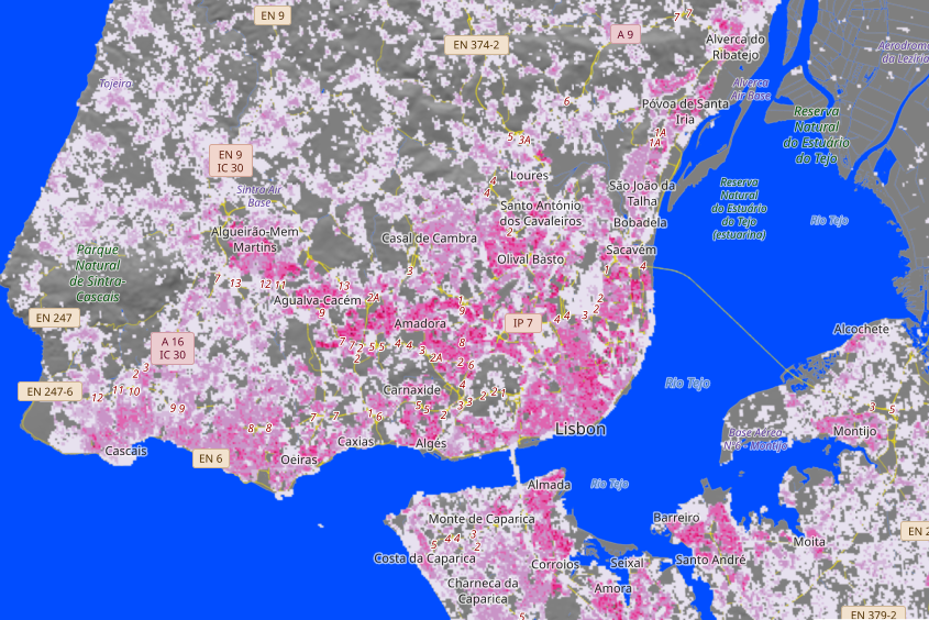
Verify the available information at GHSL –Global Human Settlement Layer, with the main objective of identifying the people at risk (ppl/Km2).
LUISA Base Map 2018 (https://publications.jrc.ec.europa.eu/repository/handle/JRC124621)is proposed to be used, as it is the most detailed, complete and consistent land use/land cover map for Europe, if no more detailed data is available. |
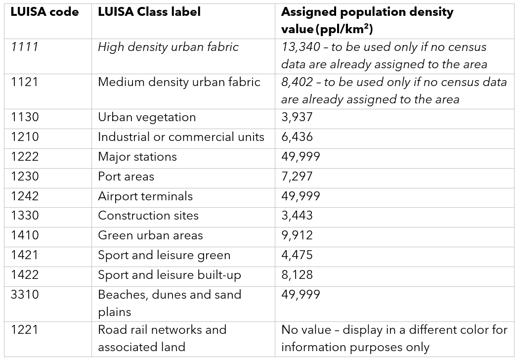
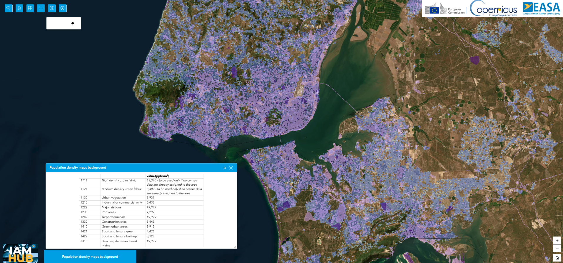
Figure 1 – LUISA land use
Link Here
Note: Not to be used for operational objectives without assessing official Portuguese sources and agreement with ANAC.
|
|
UAS Operators may also verify official data available in PORDATA, INE and DGT. This data is not specifically obtained and produced to capture the reality of the actual status of the Dpop (e.g. per skm or 100X100 grid). |
.png)
Figure 2 – PORDATA population sqm (census based)
.png)
Figure 3 – Degree of urbanisation (GSHL layer)
Note: In red areas is expected higher ground risk and dynamic fluctuations of Dpop during the day and seasons (high degree of urbanization).
.jpg)
Figure 4 – Global GSHL layer (Dopo map)
|
|
Figure 4 - Interpretation of the population density map
|
Note: Is important to consider that the probability of having spontaneous gatherings formation is very high in Portuguese cities and some villages (daily, during spring and summer season). The daily population dynamics is impossible to predict and a tactical way to assess it is required (e.g.real-time). Detailed tactical Dpop is only required if your UAS isn’t technically assessed/certified to overfly assemblies of persons in such urban areas. The UAS operator should propose when applying the method used to ensure a tolerable Dpop (as per GRC M mitigations / SORA output).
|
|
The critical area of a drone is a key element in determining the ground risk within the SORA assessment. EASA developed the Critical Area Assessment Tool (CAAT) to support applicants in the ground risk determination. The UAS operator may use the calculator to calculate the critical area of their drone, in order to demonstrate that their drone may be classified in a lower ground risk class compared to the one assigned in the SORA ground risk class table. A drone with a characteristic dimension of 3.5m may have a critical area equal to a drone with only a 3m dimension. In this case, a reduction in the ground risk class may be claimed in SORA Step#2.
|
EASA CAAT tool
https://www.easa.europa.eu/en/domains/drones-air-mobility/operating-drone/critical-area-assessment-tool-caat |
|
Dynamic population density and other services of third parties (OSO#13)-assessment-tool-caat |
The GHSL information from the preceding point must be supplemented with information on the dynamic contribution to the estimated total number of persons at risk, taking into account, for example, the time of day/season. The assessment should be done by the UAS operator.
The UAS operators should take into account possible events or festivals. Such events are organized also in sparsely populated areas and increase the iGRC due to dynamic population contribution. ANAC accept under OSO#13 tactical Dpop information solutions based in MNO technology , if SLA is available with performance information and dedicated Dpop services (based on 2019/947) to better provide a tactical insight of the number of persons at risk. Such service should be used to the UAS operator develop monitoring procedure to reroute based in the Dynamic Dpop service, including any contingency and emergency procedure required to cope with failure of the service. Therefore ANAC is available to accept solutions based in the estimation of Dynamic Dpop based in the spatial distribution of connected mobile phones from Mobile Network Operator (MNO).
Note: As per ANACOM the rate of penetration is 178 per 100 habitants , or 129,3% (1st trimester 2024) for MNO data services utilization.
If the UAS operator use a dynamic Dpop service of MNO ANAC will require SLA and up to SAIL III declaration of the performance based in the static and tactical measurement of MNO network availability, continuity and performance to ensure that OSO#13 is covered.
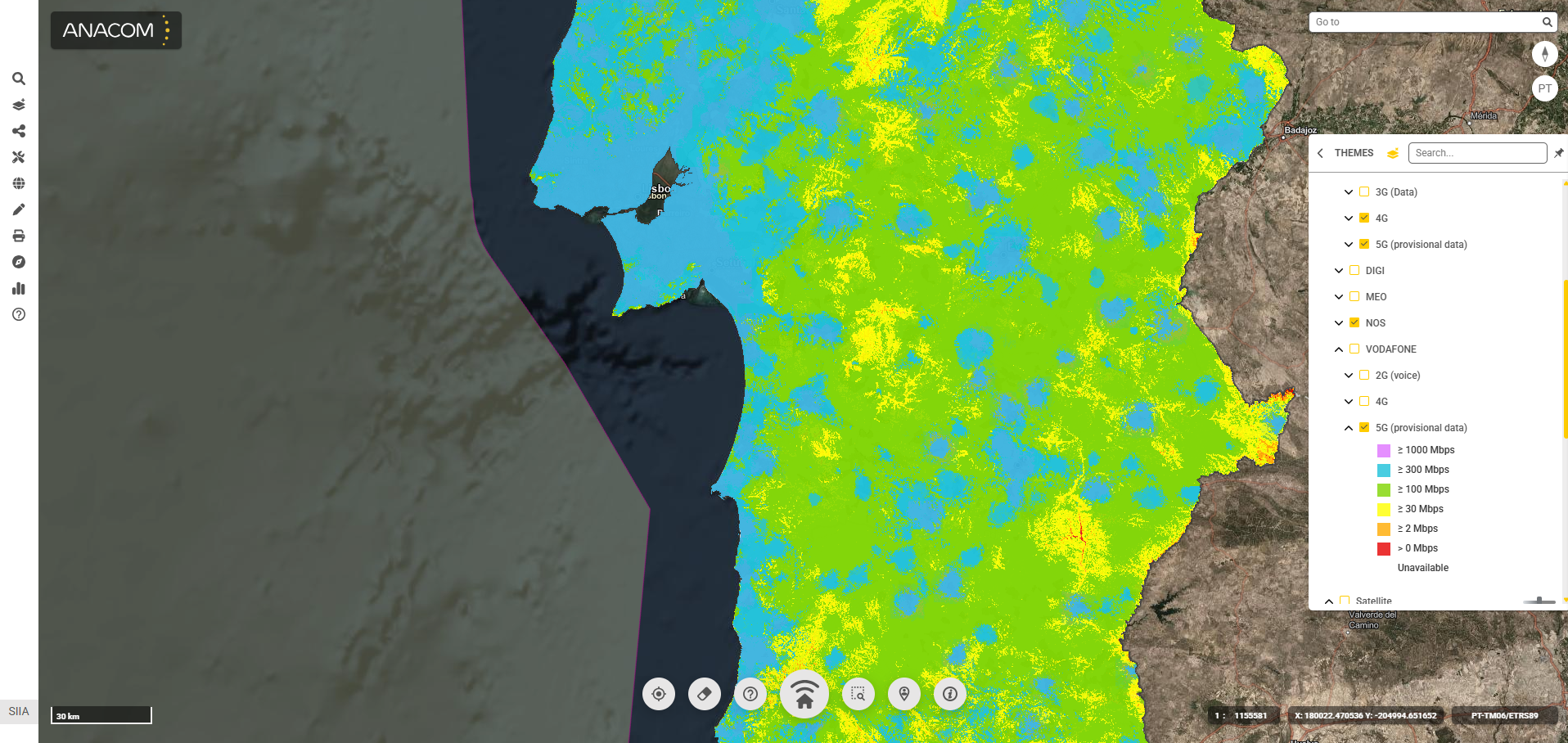
ANAC could also accept for C2 Link by using MNO (but continues monitoring is required via NETMED APP (https://netmede.pt/app) and automatic landing in case of break of link is required and prepared landing sites). NETMED app could be installed in the CMU, on board (Android, IOS, >Win 7) or used in an accessory device to provide information about the network status:
The following tools could be used:
ANACOM GeoPortal (https://geo.anacom.pt/publico/home)
- Satelite data services (Starlink, NextWeb, Quantis Global etc.)
- MNO 4G and 5G Mobile network performance
(2) NET MED APP (https://play.google.com/store/apps/details?id=pt.netmedepro.useragent.android&hl=pt)

Note: This point is also related with “4G/5G Performance” |
Figure 5 – 5G provision/availability of data MNOs
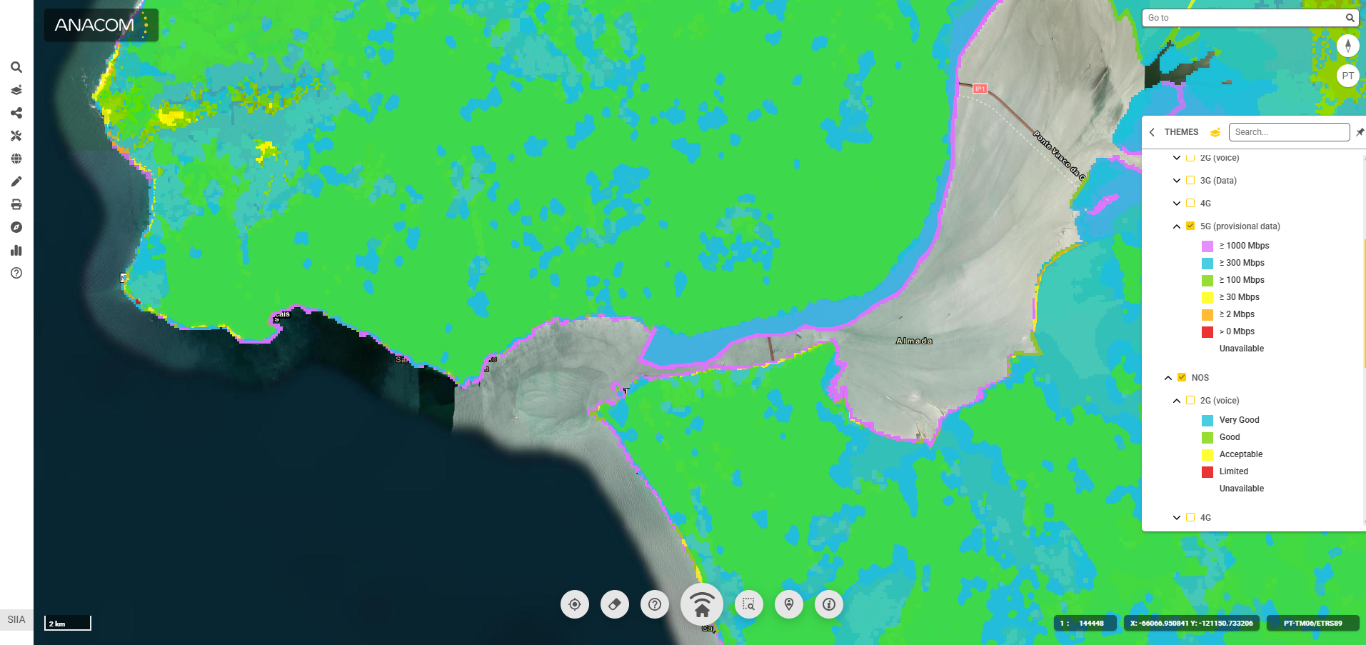
Figure 6 – Satellite data services providers / availability
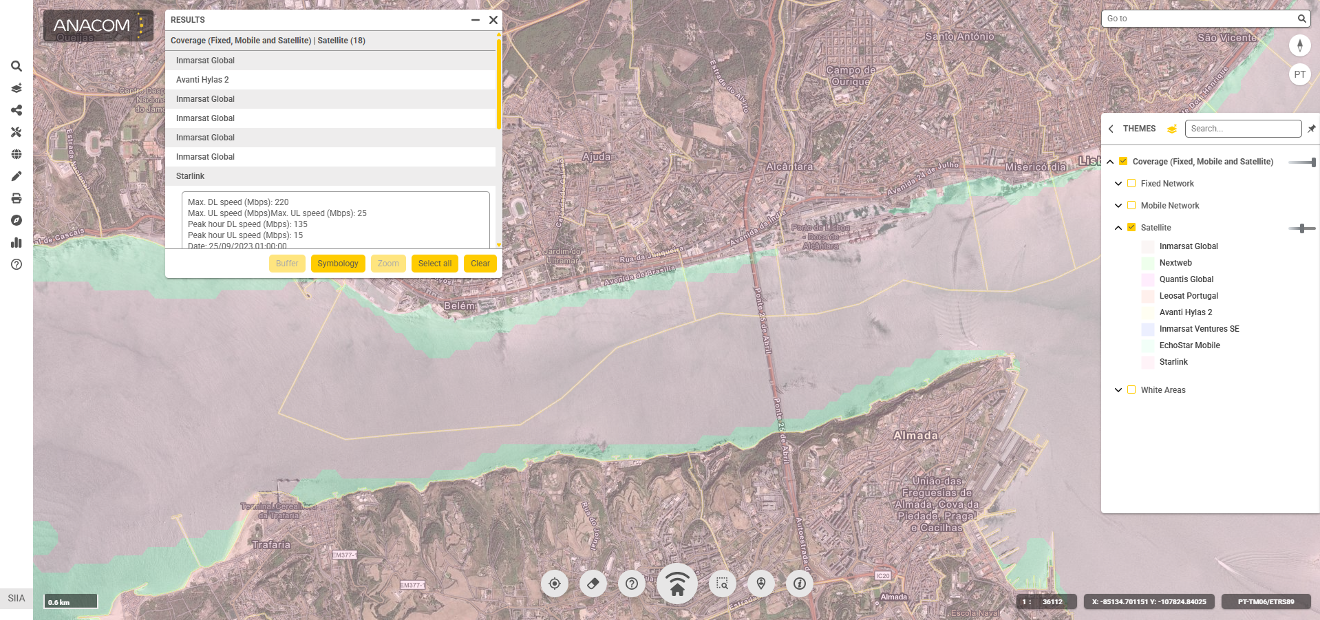
Figure 7 – NETMED MNO Network performance / satellite data providers number and distribution of measurements
Note: Ping and measurement rerouted to a server in Lisbon independently of your position in Portugal.

Figure 8– Country 4G / 5G global availability
|
|
Military ZG’s |
Coordinate with the National Military Aeronautical Authority (Autoridade Aeronáutica Nacional,AAN) to obtain an aerial surveys permit (photograph and/or videos captured by the UAS) and/or to obtain a permit to operate within an area of military jurisdiction published in eAIP as LP-R (restricted)LP-P (prohibited), LP-D (dangerous) or LP-TRA (temporarily reserved), as well as Lisbon Zone 1, 2, 3 and 4. |
AAN geographical zones is available in https://uas.anac.pt/registry/explore.
AAN, in accordance with its statutory regime, could also publish temporarily prohibited/restricted areas. These areas can only reach in AAN webpage available here.
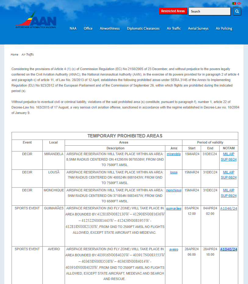
Do not fly within temporary AAN areas published as a ZEA (“Zona de Exclusão Aérea”/“No Fly Zone”) in AAN website (published also by NOTAM). Such temporary zones are implemented for internal security and military states activities.
Note: Even if a CBO is approved, in case of a AAN ZEA the UAS operator cannot start an operation unless the airspace manager of the ZG (AAN) allow the entry for that specify user. Prohibited ZEA cannot be accessed by civilian operators (open, specific and certified categories).
|
| Areas and procedures for access to natural parks |
In case you want to conduct an UAS operation in parks or nature reserves you must coordinate the entry with the environment authority manager.
Note the information is included in geozones. |
In Madeira and Azores, you could find the ED-269 file in https://uas.anac.pt/registry/explore :
- In Madeira, with the Instituto das Florestas e Conservação da Natureza (IP-RAM);
- In the Azores, with Direção Regional do Ambiente dos Açores.
In Portugal Mainland, you should contact Instituto de Conservação da Natureza e Florestas (ICNF), that also makes available a geo-catalogue (geocatálogo). This “geocatálogo” is to be considered for all activities and include entry by foot in the park since some trees, flowers and others small species are protected (hundreds of species). Since the scope is not directly related and the polygons are very complex, we strongly suggest to verify the geocatálogo and request information directly to ICNF.
|
|
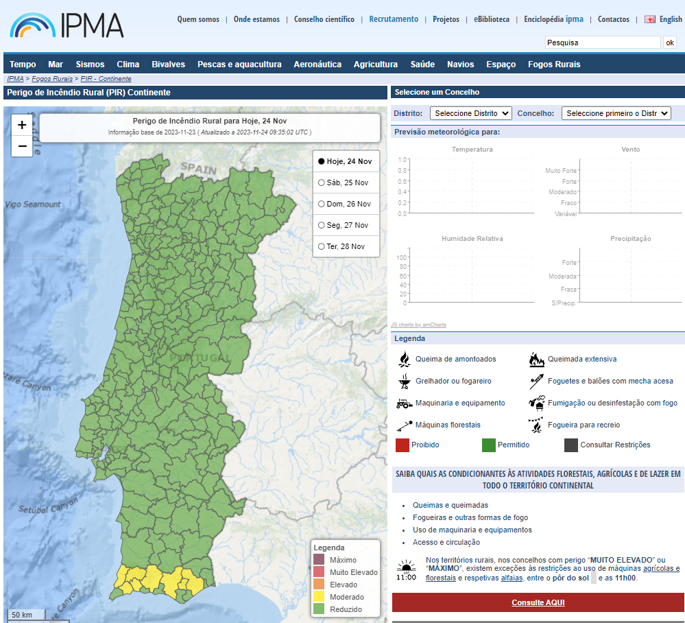
Fire Hazard / Wildfire |
Verify the available information from Agência para a Gestão Integrada de Fogos Rurais (AGIF), to confirm if the operational zone is located within a high fire hazard location. If the fire risk is “very high” or “extreme”, UAS cannot be operated in Portugal. The levels of the fire risk is moderated by IPMA and available at this page. |
https://www.ipma.pt/pt/riscoincendio/rcm.pt/
|
|
Occurrence areas/rescue (first-responders) |
Verify the available information from Autoridade Nacional de Emergência e Proteção Civil (PROCIV), to confirm if the operational zone is located inside an occurrence area. PROCIV website provides information regarding these areas to be avoided for any open or specific category operators, except if being authorised by the rescue chief.
Please note that are requirements in Part A (open category) and B that could be fulfilled if you know the location with first responders to be avoided. |
Occurrence areas available at PROCIV.
Before the flights, the operators should establish procedures to monitor and avoid these zones.
|
|
Controlled ground area in public, semi-public spaces over the terrain or over the sea or rivers (internal waters) |
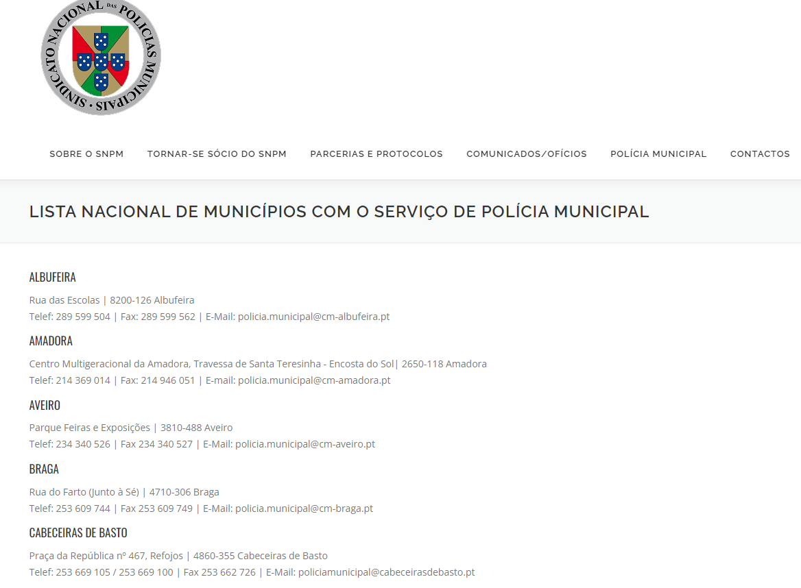
In case of the need to implement a ground controlled area (enforced area where uninvolved persons cannot access) in public places, or if the operator requires a public road closure permit issued by the City Council (the list is available on this page) in order to ensure the enforcement of the ground controlled area, the involvement of the Polícia Municipal, Polícia de Segurança Pública or Guarda Nacional Republicana could be required.
Note that there is an authorization issued by the municipality to close a public space and then you could need policeman to ensure proper enforcement (depends of expected population density). Is unlikely that an UAS operator have the resources and the authority to ensure a ground-controlled area in public urban areas or festivals where is expected assemblies of persons.
To establish a Ground Controlled Area (GCA) over territorial or internal waters, such as rivers, the operational risk assessment shall include the implementation of appropriate mitigations. In particular, the operator shall obtain prior authorization from the competent Local Maritime Authority (Capitania do Porto) whenever the operation is conducted in coastal areas, beaches, harbour entrances, harbour shelter areas, or inland waterways and GCA is required.
Where the Local Maritime Authority authorizes the establishment of the GCA over the relevant water area, such authorization may be used as evidence that civil maritime navigation will be restricted or prevented within the GCA during the approved period of the operation.
Unless documentary evidence demonstrating the establishment of the GCA is submitted to ANAC in advance,including the relevant authorizations and the specific geographical area and period of validity, for operations over terrain in public, semi-public or private areas, or over territorial and internal waters (e.g. rivers or harbours), the CBO authorization will not be issued.
In the absence of such evidence, ANAC will consider that no effective Ground Controlled Area has been established for the purposes of the local assessment output.
|
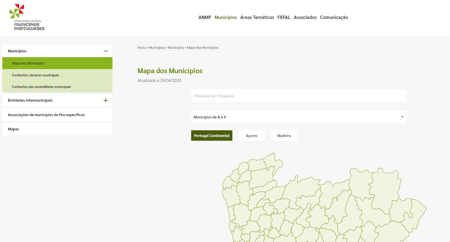
https://anmp.pt/municipios/municipios/municipios-de-a-a-v/
Note: To appraise a ground-controlled area you should demonstrate that you are able to implement it and ensure enforcement. If in urban environments in public places your local assessment should include the mitigations should be supported by the required authorizations (municipality) and evidences.
|
|
Activities on the coast/ ground controlled area on the beach or harbors entrance or harbors shelter
|
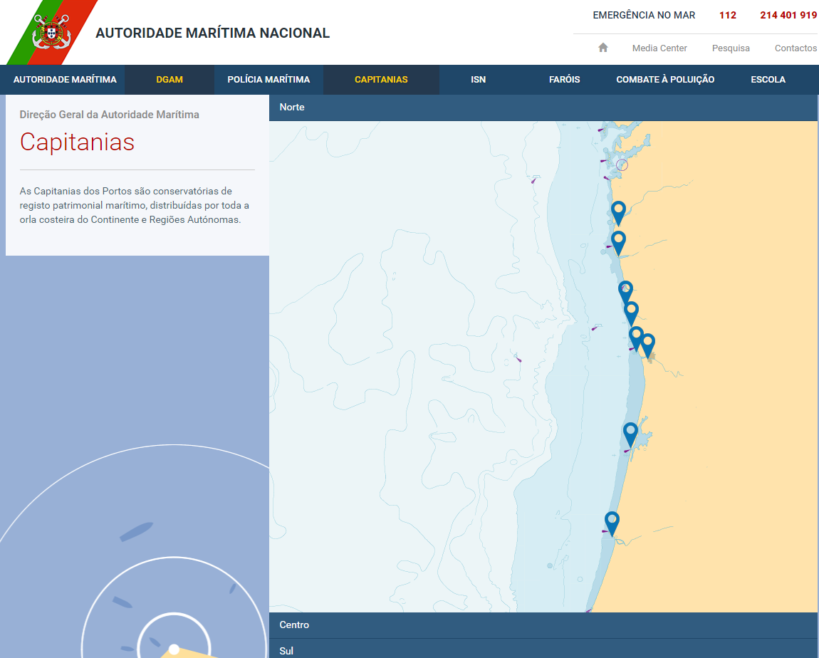
In the case of UAS operations over national waters or coastal waters, coordinate with the National Maritime Authority and its capitania, to confirm that there is no inconvenience (e.g. SAR or navy exercises).
|
In the SORA authorisation process, any operation that is within a harbor or in the harbor entrance, due to the risk (maritime traffic), ANAC will request and evidence that the UAS operator coordinated the operation with the captaincy (BVLOS, SWARMs overfly non-involved persons if not in the A1 subcategory and assemblies) and shall be provided evidence that will not be operated vessels entering and leaving the harbor (ground risk increase).
https://www.amn.pt/DGAM/capitanias/Paginas/Capitanias.aspx
In all other situations if not in the adjacent place to the entrance and if outside the harbor, marinas and sea ports, over the sea water the GRC is considered “ground controlled area”.
|
|
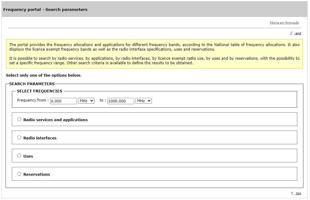
Exempted and licensed frequencies (authorisation for use) |
If using broadband wireless systems within the 5 GHz band, or if there is a doubt regarding the use of frequency bands, namely the exemptions or to use frequencies in the aeronautical band, the operator shall verify the information available from Autoridade Nacional de Comunicações (ANACOM).
Note: To use the Aeronautical band, including to use VHF frequencies in order to implement a tactical contact with a ATS unit (e.g. if tactical coordination required with high performance do to the operation in close proximity with an Airport), is required:
-ANACOM approvals as per national law, including the possibility to use a VHF radio to contact the ATS unit;
-Competent personnel that hold a valid Radio operator license (phraseology and radio telephony technique);
-Additionally, the ATS must agree to participate (if the air traffic allows it) the utilization of a back-up secondary VHF frequency, segregated of the real operation, to be used and monitor only by a dedicated ATCO or ATCO SUP during the duration of the UAS flight. The shift in the tower must be suffice to participate in such coordination and the ATS needs to accept.
If the conditions aren’t meet will not be approved by ANAC.
|
eQNAF frequency Portal (ANACOM)
|
|
4G/5G Performance |
The UAS operator could use ANACOM NETMED to verify the mobile telecommunication performance of the mobile operator. |
NETMEDE Maps and Test app (laptop/android/IOS)
In case you are using a third-party service for command and control (via 4G/5G) you should assess impacts in OSO #13 and adjust it to the Portuguese reality (since the service providers are different and the performance of 3rd party service is different).
|
|
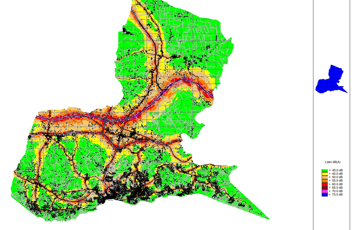
Noise |
The UAS operator should also be aware of national noise law, noise limits and the municipality noise maps, which are published for cities with infrastructure that may be a source of noise (airports, railway etc) and in populous cities. The municipality noise maps are available here. |
Municipal noise maps
|
|
Terrain
|
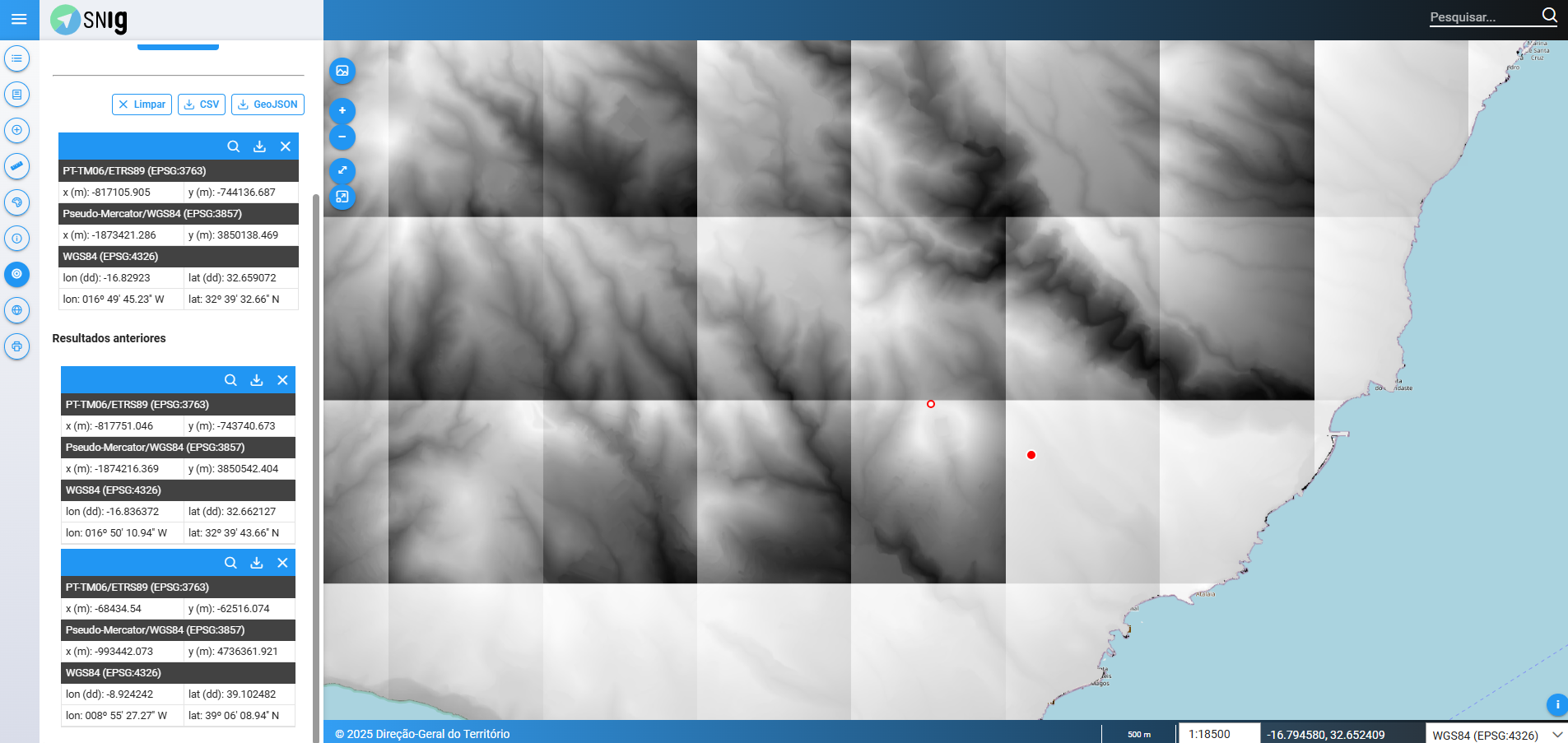
The Digital terrain, elevation and other geographic information models are made available by Direção Geral do Território (DGT). We suggest the operators to consult the national data in the following page.
DGT provide Digital terrain model surveyed by Lidar march 2025.
|
For general geo information services
https://snig.dgterritorio.gov.pt/mapa/snig
Note: Option to export Metadata is available
Note: Option to export Metadata is available
For the most updated DTM:
https://www.dgterritorio.gov.pt/cartografia/cartografia-topografica/modelos-digitais
|
|
Weather/Meteorology |
IPMA
In case you need certified meteorological information, you could consult IPMA webpage.
|
https://www.ipma.pt/pt/index.html |
|
Airspace coordination Procedure ATSp |
NAV Portugal E.P.E.
espaço.aéreo@nav.pt |
Only for UAS operators under the specific category and for purposes of paragraph b) of paragraph 1 of UAS.SPEC.040 (Coordination procedure with ATC) of Implementing Regulation (EU) 2019/947 and obtaining information for the purpose of the air risk for the SORA process.
In case of a CBO application and a procedure is in place to coordinate with the ATC, that procedure must be agreed with ATC unit and the OM must be updated accordingly. The agreed procedures for the coordination process must be integrated in the OM.
|
|
Airspace allocations (e.g. NOTAMs) |
CIA n.º 29/2013 of ANAC established the process for airspace allocations. |
As per local conditions ANAC authorization is always required in case an airspace allocation is required as per CIA 29/2013 point 6.2.1. The allocation of airspace for a specific user is limited in dimension and time and must ensure an efficient use of the airspace. Additionally, airspace complexity should be avoided as per Portuguese SSP 2022-2024. An airspace allocation is always the final solution and a proper plan must be provided by the UAS operators that appraise risk reduction by airspace allocation specifically for is activity. Nevertheless, if the UAS operator have in the OAT or LUC privileges the airspace reservation as a mitigation, a proper planning must be provided to ANAC to assess if an efficient utilization is possible. If the probability of airspace infringement is higher or the possibility of utilization by other users is also high a DAA process could be requested to ensure a safety barrier for GAT pilots, SPO operators and state entities.
|
|
Making available, possession, transport, storage and use of pyrotechnic articles |
The possession, transport, storage and use of pyrotechnic articles, including during flight by a UAS, require compliance with Regulation 01/2025 of 2 January. This regulation sets out the conditions and rules for the conduct of pyrotechnic displays by pyrotechnic companies, using pyrotechnic operators, as well as the conditions relating to the assembly and use of authorised pyrotechnic articles. A UAS operator wishing to use a UAS in a pyrotechnic display, with fireworks on board, requires prior authorisation from the PSP. After obtaining such authorisation, the operator may use the implemented mitigation as evidence within the scope of the local assessment. Pyrotechnic displays may only be carried out under a licence granted by the competent police authority pursuant to Article 38 of the RFACEPE.
|
|
|
Insurance
|
Decree-law 58/2018 23 of July (mandatory insurance)
Ordinance n.º 2/2021 4 of January (insurance limits) |
As per local conditions you need to have third party liability insurance as follows:
- <900g recommended but not mandatory
- 900g up to < 1,5Kg 0,26DSE (FMI)
- 1,5Kg up to < 4Kg 0,38DSE (FMI)
- 4 up to <20Kg 0,56 DSE (FMI)
- 200Kg or more 0,75DSE (FMI) and according with Regulation (UE) 785/2004 updated version.
|
|
Minimum age
|
Decree-law 87/2021 20 of october |
Minimum age is 16 years old. No ANAC regulation is available reducing the age as per n.º 2 article 7 of national decree-law. |